One small job for NASA, one giant map for mankind
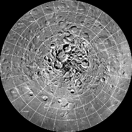
 NASA has released a high resolution recreation of the Moon’s north polar region, allowing intrepid internet users to explore the lunar surface form the comfort of their computer chairs.
Cameras aboard NASA's Lunar Reconnaissance Orbiter (LRO) were used to capture 10,581 still images covering around 3 million km2 of the Moon.
The images were then painstakingly stitched together by a NASA team to complete a mosaic with enough detail and consistent lighting to see textures and subtle shading across the lunar terrain.
“Creation of this giant mosaic took four years and a huge team effort across the LRO project,” said Mark Robinson, principal investigator for the LROC at Arizona State University in Tempe.
“We now have a nearly uniform map to unravel key science questions and find the best landing spots for future exploration.”
The entire image measures 931,070 pixels square, nearly 867 billion pixels in total, and would require approximately 3.3 terabytes of storage space to be saved as a single file.
The images making up the mosaic were taken by the two LRO Narrow Angle Cameras, which are part of the instrument suite known as the Lunar Reconnaissance Orbiter Camera (LROC). The cameras can record a tremendous dynamic range of lit and shadowed areas.
Researchers used additional information about the moon's topography from LRO's Lunar Orbiter Laser Altimeter, as well as gravity information from NASA's Gravity Recovery and Interior Laboratory (GRAIL) mission, to assemble the mosaic.
Launched in September 2011, the GRAIL mission, employing twin spacecraft named Ebb and Flow, generated a gravity field map of the moon - the highest resolution gravity field map of any celestial body.


 Print
Print