


Black Sea shipwrecks revealed
 Print
Print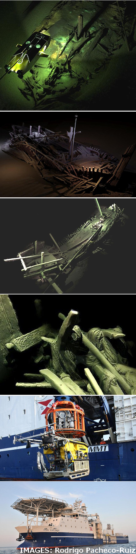 Robots scanning the seabed have stumbled on a stunning set of ancient shipwrecks.
An exploration ship called the Stril Explorer - which carries some of the most advanced underwater survey systems in the world - has been scouring the waters 1,800 metres below the surface of the Black Sea as part of an expedition to map submerged landscapes.
The Black Sea Maritime Archaeology Project (Black Sea MAP) is seeking to answer some hotly-debated questions about when the Black Sea’s water level rose after the last Ice Age, how rapidly it did so and what effect it had on human populations in the area.
The primary focus of the project was to detect former land surfaces buried below the current sea bed, taking core samples to build a palaeoenvironmental reconstruction of Black Sea prehistory.
But as researchers were using Remotely Operated Vehicles (ROVs) to survey the sea bed, they came across a field of more than 40 ancient shipwrecks from the Ottoman and Byzantine periods.
Many of the ships were of a kind that had only been seen in historical pictures, but never found intact.
The ships help provide new information on the communities on the Black Sea coast.
Most of the colonial and commercial movements of ancient Greece, Rome and the Byzantine Empire required crossing the Black Sea.
The team was able to gather incredible details on the shipwrecks using an ROV optimised for high resolution 3D photography, partnered with another that carries an entire suite of geophysical instrumentation, lights, high definition cameras and a laser scanner.